Crappy fall weather
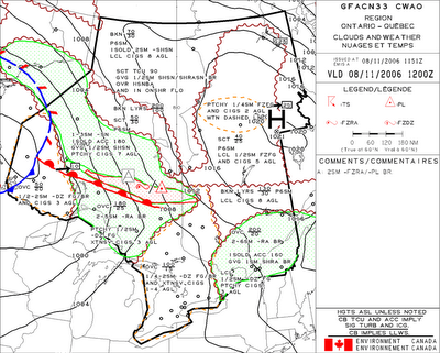
Looking around Souther Ontario the weather would be described as Poo Poo. That is a technical aviation term meaning crappy :) As you can see in the above image which is from Environment Canada and is an Aviation Graphical Area Forecast (GFA) there is a warm front (the red line with humps on it) extending from around the Manitoba border east south east towards Timmins. Now you can also see lines on the map, these are isobars (lines of equal atmospheric pressure) and depending if they are around a Low (which in this case is just off the map around Winnipeg) or a High pressure (the big H over Quebec) the wind moves parallel to these lines of equal pressure (above 3000 feet because near the surface, surface friction and the sorts cause them to angle in towards the low or away from the center in a high). Around a Low winds circulate counter-clockwise. So in this case the winds are coming from the south west in effect pushing the warm front up. Around a high pressure the winds rotate clockwise around the center of pressure which in this case means the High over Quebec is moving air in the same direction as the low pressure. Now basically what is happening is warm moist air is coming up from the south and meeting some cooler air and causing it to condense and cause bad visibility and low ceilings over Southern Ontario. I am really skimming the surface here but today the weather is quite bad over a large area so I wanted to write about.
Practical Application
Now if I was planning a trip today I would first go to Navcanada's weather site and put in my route of flight so that it will pull up METARS (basically weather observed within 5 miles of the aerodrome) and is updated hourly. It also comes up with TAF's (Aerodrome forecasts which cover within 5 miles of the aerodrome and give predicted winds, visibility and ceiling.) Now today I would pull up the following weather.....
SPECI CYOW 081433Z 09008KT 1SM -RA BR OVC002 07/ RMK FG2ST6=
To decode this first Metar...
It states that a SPECI (special weather observation because conditions changed from the hourly report by a predetermined amount as per there weather manual) CYOW is Ottawa International Airport.
081433Z is the 08th day of the month at 1433Z (Universal Time Co-ordination or Zulu time)
At the time of the observation the winds are from 090 degrees True (not magnetic) at 8 kts.
Visibility is 1 statue mile in light rain and mist, ceiling is overcast at 200 feet above ground (minimums on an ILS) Temperature is 7 degrees (normally there is a dew point but on specials usually the main weather that has changes is listed. RMK is in the observers remarks, 2/8's of the sky is Fog and the other 6/8's of the sky is stratus could. Now there gets to be some different rules to denote a ceiling 5/8's of the sky has to be covered with cloud but whenthere is fog (which is a surface based cloud) then it changes a bit. Click here to go to the Weather Observers Manual.
SPECI CYOW 081433Z CCA 09008KT 1SM R07/5500FT R32/4500FT -RA BR
OVC002 07/ RMK FG2ST6=
METAR CYOW 081500Z 09006KT 1/2SM R07/4500FT R32/4000FT -RA FG OVC002
08/07 A2978 RMK FG4ST4 SLP087=
SPECI CYOW 081526Z 10006KT 1SM R07/6000FT R32/4500FT -RA BR OVC002
08/ RMK FG2ST6=
Now when you check the weather it always gives (usually) the last 4 or so observations. The reason is to see the trendof what the weather is actually doing, and to compare it to the TAF (forecast). So the following forecast for Ottawa says:
TAF CYOW Issued on the 8th day at 1439 Zulu Valid (time when it comes into effect and for how long) on the 8th day from 15 Zulu to 12 Zulu (almost 24 hours). Winds are going to be out of the east at 090 degrees true at 5 kts, 1 statue mile in light rain, light drizzle and mist. Ceiling is going to be 200 overcast.
Now since it covers 21 hrs it continues on to describe the rest of the day....
TEMPO (means temporarily) temporarily between 15 and 22 zulu (10am local to 5pm local) conditions can be
up to 2 statue miles in light drizzle and mist overcast ceiling of 400 feet. So if you were a VFR pilot you would just read the forecast and go home for the day.
FM2200Z means From 2200zulu (From means a definitive change in conditions unlike the tempo because weather can go up and down and you want to know how good or how bad its gonna be)
So from 2200 Zulu winds are the same out of the east at 5 kts but it will improve to be 2 statue miles and mist and a broken ceiling of 200 feet and overcast at 1000 feet above ground.
From 0200Z its going back down again to 1 mile and overcast at 200 and even getting worse down to variable winds less then 3 kts 1/4 of a mile (or 1200 feet vis which is minimums on an ILS) in Fog the ceiling with be a vertical visibility through the fog to be 100 feet. Yeah so getting bad and staying that way.
Now in the remarks section at the bottom it says stay tuned because the next forecast comes out at 1800Z or 1300 local time. They will be taking in new weather observations till then, checking with forecasts models and will issue the next 24 hours.
TAF CYOW 081439Z 081512 09005KT 1SM -RA -DZ BR OVC002 TEMPO 1522 2SM
-DZ BR OVC004
FM2200Z 09005KT 2SM BR BKN004 OVC010
FM0200Z 09005KT 1SM BR OVC002
FM0600Z VRB03KT 1/4SM FG VV001
RMK NXT FCST BY 18Z=
SPECI CYXU 081429Z 28002KT 1/4SM R15/2200FT/N FG VV001 10/ RMK FG8=
Just a quick decode for London Ontario (CYXU)...
Observation at 1429Zulu, winds 280 true at 2 kts, 1/4 mile visibility R15(runway 15) RVR (runway visual range)
2200 feet /N means its neutral not getting better or worse. and FG or Fog is causing the reduced vis. Vertical
Visibility is 100 feet. Temperature is 10 and Remarks Fog in all 8 quadrants of the sky from the observers viewpoint.
SPECI CYXU 081439Z 29002KT 3/4SM R15/2800VP6000FT/U BR OVC002 10/ RMK
FG6ST2=
SPECI CYXU 081439Z CCA 29002KT 3/4SM R15/2800VP6000FT/U BR OVC002 10/
RMK FG6ST2 VIS E-SE 1/2=
METAR CYXU 081500Z 00000KT 1SM R15/P6000FT/N BR BKN004 10/10 A2970
RMK FG2SF5 SLP062=
SPECI CYXU 081521Z 00000KT 2SM BR BKN003 BKN007 11/ RMK FG2SF3SC2=
SPECI CYXU 081536Z 26003KT 3SM BR BKN006 11/ RMK FG2SF5=
TAF CYXU 081141Z 081212 VRB03KT 1/4SM FG VV002 TEMPO 1215 1SM -DZ BR
OVC005
FM1500Z VRB03KT 1SM BR OVC004 TEMPO 1517 3SM BR OVC008
FM1700Z 18005KT 6SM BR BKN008 OVC015 TEMPO 1720 P6SM NSW OVC015
FM2000Z 18005KT P6SM OVC015
FM2200Z 22005KT P6SM BKN020
FM0200Z 22008KT 2SM BR BKN008
FM0400Z 22008KT 1/2SM FG VV002
FM0600Z 22008KT 1/4SM FG VV001
RMK NXT FCST BY 18Z=
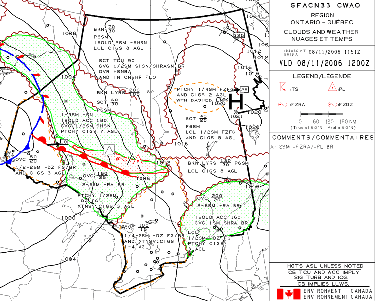
So what you can see if the weather is very poor throughout the area and the visibilities are going up and down because of fog rolling around. So after I look at what the actual weather is doing I look at the forecasts to see if what I am actually seeing is what the forecaster predicted would happen. If I was looking at 1/2 a mile visibility and overcast at 100 feet and the forecast was calling for sky clear then I would wanna double check the forecasts as they will be amended...it happens alot in the Arctic along Hudson Bay in such places as Rankin Inlet. When the cold air moves in and the bay is still not frozen over, a slight change in wind direction can cause fog to roll in and the airport will be unusable for hours. So you will see the poor forecaster re-issuing amended forecasts all the time this time of year. So to get a big picture of what is going on I look at the GFA which I put at the top of the post. It describes in 6 hour segments the positions of all surface fronts, low pressure centers, high pressure centers, and all associated clouds and weather with it. It covers a huge area but generally lets you know why the actual and forecast weather is the way it is. If you look at the GFA at the top there is a huge area surrounded by yellow hatchings. This lets you know that there is obscuration's to visibility other then precipitation. Today that phenomenon is fog and mist along with light drizzle. In the caption in the center of the yellow hatched area around North Bay it says..... Overcast ceiling from 1500 feet (above sea level as it covers a large area) topped at 10,000 feet above sea level. This tells me if I was to take off out of Ottawa I would be climbing through cloud until 10,000 (this is a forecast and it could be less or more). Now if its close to freezing on the ground I could expect with all the moisture in the air to probably pick up some ice on the airframe. Now if you continue to read it states 1/4 to 2 statue miles visibilities associated with light drizzle, fog and mist. Continuing on it states that there will be extensive ceilings 1oo to 400 feet above ground. So if you put all of the pieces together you get a puzzle that fits together perfect. The metar's show weather going up and down to what the TAF is calling for and the GFA backs it up and the puzzle is complete. Sometimes the GFA will be saying one thing and the forecasts another. I remember one time deciding if I should go out to a lodge up in northern Manitoba in the Caravan. The forecast was looking great and worst case scenario was something like 1000 feet better then 6 miles visibility and the odd light snow shower. But that was just my departure airport...I then looked to an airport about 150 miles to the west and the ceiling was down to 200 feet moderate snow and about 1/2 a mile in vis. By this time they had the same forecast as my departure airport and it was suppose to be not bad weather at all. So I looked at the GFA again and the cloud layers that the GFA was calling for was about 50 miles off and about 3 hours early so it was getting worse then previously thought. All of a sudden it was down to 1 mile in snow and 400 feet and the snow started to dump and ceilings got as low as 100 feet. Forecasts got all amended and the rest of the day was a write off for me and back to bed I went ! I was sure glad that day to kinda double check things before I got stuck out there scratching my head thinking I really wish I hadn't left and what am I gonna do now.
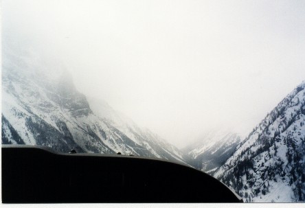
What I have learned so far is that when you feel things aren't adding up....they aren't. Here is a picture of when the gut feeling was reaffirmed by a wall of cloud and snow showers flying through the rockies....go with the gut instinct!

Sorry for my incoherent jumping around but there is just so much to discuss when it comes to weather.
CheersFD
2 comments:
Ha ha... now do I miss the weather?? In NZ...nice blog
Your blog post title says it all! I have been stuck in this same pattern, flying cargo at night between Ohio & Hamilton, Ontario over Lake Erie. Last night was the worst... had to divert for vis, ceilings & missed a stop on my route. Got home 3 hrs later than usual & spent lots of time wondering when things will improve.
Post a Comment